Know More
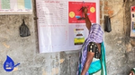
Build water numeracy to quantify availability, budget, and allocation of water resources through widescale deployment of low cost technologies and tools.
Our programmes recognise the diversity of India’s water challenges across hydrogeological zones, river basins and agro-climatic conditions. This diversity mandates a range of solutions instead of a 'one solution at scale' approach.
With communities and farmers at their core, our programmes have delivered solutions that can help them 'Know More' about their critical water resources, 'Save More' using scientific conservation methods, and 'Use Less' water in agriculture.
Build water numeracy to quantify availability, budget, and allocation of water resources through widescale deployment of low cost technologies and tools.
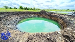
Equip communities to lead scientific water conservation efforts through GIS and digital tools for planning, measurement, monitoring, and governance.
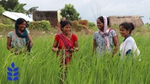
Drive behaviour change for responsible water use by demonstrating and encouraging adoption of sustainable irrigation practices, input use, soil health and crop choices.
HUF’s water conservation initiative partners with civil society organisations and multiple co-funders (including government). The programmes span across 15,500 villages in 14 states and 2 union territories across India.
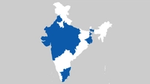
Disclaimer: Map of India should not be used for navigation or legal purposes. It is intended as graphical design element and does not warrant the Map or its features to be either spatially or temporally accurate. Hindustan Unilever Foundation does not claim the correctness or authenticity of the same.
At HUF, we have adopted a robust protocol by partnering with civil society organisations to measure the outcome of our programmes which includes various crucial indicators. These include the quantum of water potential created through conservation efforts and improved agricultural practices.
We also measure the economic benefits to farmers through yield and income improvement. Further, we look at the effectiveness of community-led institutions on the governance of shared water assets, as our aim is to make the community self-reliant, and self sustaining. These outcomes are validated through independent third-party audits.
The cumulative impact of HUF’s programmes (independently assured up to 2022-23) is as follows:
of cumulative and collective water potential created up to the year 2024
of agricultural and biomass production generated until the year 2024
generated up to 2024 through community water conservation projects
Find out more about our individual programmes and impact.